
Monday, February 29, 2016
Monday, February 22, 2016
Party Under The Bridge
Feb 20, 2016
 We headed out shortly after 11 am on what I considered too windy of a day. I admit that I am kind of a fair weather rider and I am not ashamed to say it either! (It doesn’t make me any less of a biker :P) I just don’t particularly enjoy being blown around on my bike like a rag doll that’s all. But lately Florida just hasn’t had the most pristine conditions so if I was going to ride at all this year I would have to set aside my numerous 'fair weather' riding rules and suck it up by adding a heavier hoodie under my jacket and just brave the wind.
We were heading off to check out a ‘Party Under The Bridge’ in Moore Haven today. I knew that the route we were about to travel wasn’t going to be the nicest to ride on with the exception of the scenic River Road. Not to say that the road condition isn’t good, it is just that these secondary highways are flat, open and mostly straight with speeds in excess of 60 miles an hour -which by the way is the posted speed limit that no one adheres to - then add a strong crosswind and you get the picture.
 This ‘Party Under The Bridge’ is in it’s 7th year as an annual fund raiser and is put on by the local legion in Moore Haven to benefit the veterans. To be honest I wasn’t expecting much, but was pleasantly surprised to see the huge turn out that was there considering that this town has had it’s share of misfortune and despite it being humbled by two Hurricanes. The first hit in 1926 and the other in 1928, the latter eventually destroyed what was left of this once boom town which was known as ‘Little Chicago’ at the time. Seeing it now, it was hard to image it as a rapidly growing and prosperous community... but I got the feeling that there is still a lot of pride with the people who still reside here.

There is also one other draw that might interest some to take a ride out into the middle of nowhere. On the first Saturday in March there is a festival called the ‘Chalo Nitka Festival and Frontier Days’ [Chalo Nitka means “Big Bass” in the Seminole Indian language] . The festival and rodeo dates back to 1948 when it first originated to commemorate the paving of Main street in Moore Haven. (Anything for a party) It has now become one of the longest running festivals in Florida. I suppose it may warrant another trip out that way to check it out.
 We checked out the various booths containing the usual ‘biker’ festival fare. The festival is held directly under the bridge that crosses the Caloosahatchee River and spills out into the street along Avenue J. The road was blocked off so you can wander in the middle of the street, however be aware of the bikes.
 I snapped this picture of an interesting feathered hat (or should I say ‘head dress’) from one of the vendors. His partner leaned over and shouted above the roar of the band playing to tell me that if he had $10 for all the people who have took a picture of his buddy he would have $100 by now. (Maybe that was a hint - I didn’t pay him any money for taking the picture)

Then we seen what I suppose was considered the ‘oldies car show’ however there wasn’t too many entries, maybe we were just early... although that jalopy looked like it has seen better days.

Next we headed over to the Lawn Tractor Pull, I have never seen one before. Interesting to say the least. This is exactly how I pictured it would be... even women get in on the act.


Afterwards we walked back to the main area under the bridge where the band Desperado was blasting out country tunes. Even though I am not a country music fan, I have to admit the band was good, but a little too loud for my liking.
 We decided that we were ready to head back and took off towards 78 but decided to turn off onto Ortona Rd to check out the Ortona Locks. It was a nice little side trip to see this part of the Caloosahatchee Canal. There was not another soul around and the quiet of the area was a peaceful interlude before we headed back out on the highway.
Enjoy the tranquil picture show...


It was still extremely windy all the way home, and I was glad when we pulled in the driveway at our designated Drink Time (3 pm)
Time to plan our next adventure...
 Cruising through life and enjoying the ride...

We were heading off to check out a ‘Party Under The Bridge’ in Moore Haven today. I knew that the route we were about to travel wasn’t going to be the nicest to ride on with the exception of the scenic River Road. Not to say that the road condition isn’t good, it is just that these secondary highways are flat, open and mostly straight with speeds in excess of 60 miles an hour -which by the way is the posted speed limit that no one adheres to - then add a strong crosswind and you get the picture.


There is also one other draw that might interest some to take a ride out into the middle of nowhere. On the first Saturday in March there is a festival called the ‘Chalo Nitka Festival and Frontier Days’ [Chalo Nitka means “Big Bass” in the Seminole Indian language] . The festival and rodeo dates back to 1948 when it first originated to commemorate the paving of Main street in Moore Haven. (Anything for a party) It has now become one of the longest running festivals in Florida. I suppose it may warrant another trip out that way to check it out.

 I snapped this picture of an interesting feathered hat (or should I say ‘head dress’) from one of the vendors. His partner leaned over and shouted above the roar of the band playing to tell me that if he had $10 for all the people who have took a picture of his buddy he would have $100 by now. (Maybe that was a hint - I didn’t pay him any money for taking the picture)
 |
| Sea of Bikes |

Then we seen what I suppose was considered the ‘oldies car show’ however there wasn’t too many entries, maybe we were just early... although that jalopy looked like it has seen better days.

Next we headed over to the Lawn Tractor Pull, I have never seen one before. Interesting to say the least. This is exactly how I pictured it would be... even women get in on the act.


Afterwards we walked back to the main area under the bridge where the band Desperado was blasting out country tunes. Even though I am not a country music fan, I have to admit the band was good, but a little too loud for my liking.

Enjoy the tranquil picture show...


Time to plan our next adventure...

Monday, February 15, 2016
To The Everglades...Not Quite
 |
| Everglade Seafood Festival (2015) |
The temperature climbed high enough today that finally it was going to be somewhat of a decent day. My plan was to head down to the Everglades for the Everglade Seafood Festival but first take a few detours while we were down that way. Honestly I was more excited about the detours. (as for the festival, we have been many times before and I wasn’t going to bore you too much by writing about it again, unless something really cool happened <grin>).
The first detour was to be the smallest Post Office in the United States located in Ochopee on Tamiami Trail [FL-41]. The last time we were there I was on my Yamaha V star 250 and my BF on his Honda . I have been wanting to get a photo op of the Harley’s in front of it ever since we got the bikes a few years back. The next place I wanted to visit was the Skunk Ape Research Headquarters, this is where a man named Dave Shealy spends his time looking for a creature that supposedly lurks in the Florida Everglades. Although I believe it is just a kitchy way to attract tourists to his Campground...or is it ... <smile> Anyway it would be good for a laugh. Next, onto the festival in Everglade City. My BF had never sampled any of the tasty treats offered and wanted to get some shrimp or something fishy this time around. (as I am not and never will be a fan of seafood I was going to pass on the taste test) Afterwards, I wanted to head over to Chokoloskee Island which is situated just past Everglade City. Sounded like a good day of riding and sightseeing to me...
So at 11 am off we went, it was still a little on the cool side for me, so I was glad I had left my jacket liner in and wore my hoodie.(after all it was only 70 F) We headed on down FL-82 to get to FL-29 (FL-29 brings you to Everglade City). I really don’t like driving on either of these roads, in my opinion they are the worst in all of Southwest Florida, but to get to where we wanted to go there wasn’t any other choice - at least that I know of. We waited until we passed the town of Immokalee to top off the tanks before heading down the long stretch of 29.
(Map shows location of Everglade City)
 |
| At the Auto Parts store |
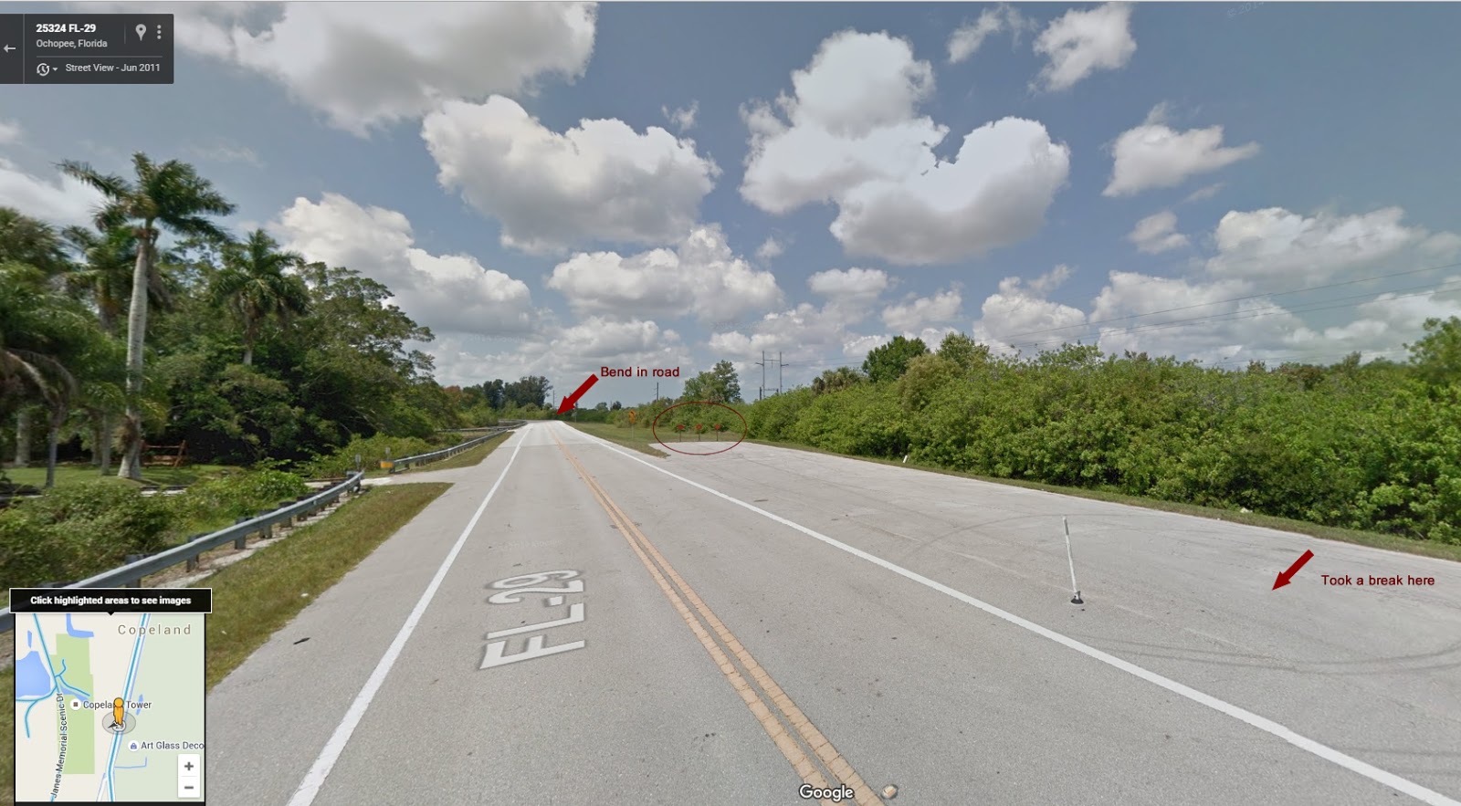 |
| I forgot to snap a pic..so this is compliments of Google |
 |
I figured it out on the map when we got home that we were a mere 2.5 miles to the intersection of FL-29 and FL-41 - the place we were going to turn for the first detour. On any other day it showed it would of taken 3 minutes!
 |
| Compliments of another Google Map - Entrance to Janes Memorial Scenic Dr. |

As we headed back my BF made a turn down a road called Janes Memorial Scenic Dr. and stopped to pull out the map. We realized we could cut through Fakahatchee Strand State Preserve which would take us back into Immokalee. Great, at least we could take a nice scenic ride and salvage some of today’s ride...


That was just great, maybe we could find another road so we pulled into the information center to have another look at the map. Again luck was not with us, so back to plan C, driving all the way back on FL-29. If nothing else at least we found a new road to eventually ride...when it dries up!
The rest of the way home was uneventful and we finally pulled in the driveway going on 4pm.
Drink Please!!!
Just goes to show, even the best laid out plans can change. But even when things change, when on a bike any ride is a good ride...

Until next time...
Cruising through life and enjoying the ride...
Thursday, February 4, 2016
Corkscrew Rd onto the Beaches
::Tuesday Feb 2, 2016 ::
This is the kind of ride for those of you who like to pass through the action, get caught up in stop and go traffic and sweat you’re a** off when in full riding gear. Not recommended doing this ride during March when it really becomes congested with us Snowbirds. <grin>
The morning started out quite foggy, but by the time we were heading out the fog had burned off and it was turning out to be a nice day for a ride. Maybe a little too nice... Finally, the long awaited (somewhat) full-day tour since arriving in Florida.
I was really looking forward more to just the ride than actually having any destination to go to, so I chose this ride simply for that. We left shortly after 11 am and after making a quick stop to fill up my gas tank (a one tank ride) we were on our way heading out onto the dreaded Immokalee Rd. [82] in order to get onto Corkscrew Rd. (Where I started this ride on the map above)
Road Details
[Immokalee Road [82] is a two lane highway, and definitely not the most relaxing road to drive on. I have mentioned before that there are more accidents than there should be on this road. They drive way too fast and pass recklessly when they shouldn’t. There is a bit of construction going on now so I think they might be enlarging it, hopefully that will help this dangerous road and not hinder it. At least we didn’t have to stay on it long before hooking onto Corkscrew Road, which is a fairly fun road to travel on, it has some twists and turns, with one in particular which is pretty much a 90 degree corner. The road is paved and for the most part in good condition. There are some rough patches but really nothing to worry about. It is quite a “fast road” as the speed limit is 55 mph (88 km) and depending on the time of day you motor through just be aware that there are some very large trucks that use this road and they have a tendency to pass you like your standing still. (Even if you are going a little over the speed limit yourself. <smile>) You will pass through a lot of farmland and panther habitat on this route before coming to the more populated area where the gated communities take over.]
As we headed along Corkscrew Rd. we made a stop at the CREW Marsh Trails.
 {FYI: The Corkscrew Regional Ecosystem Watershed is 60,000 acres of land that collects, stores and cleans water for southwest Florida's drinking water supply. It also is a habitat for many threatened or endangered plants and animals. According to the signs posted the Florida panther, black bear, snail kite, gopher and tortoise along with species of rare ferns and orchids all make this area their home.}
 If you are inclined to be one with nature this place has a fairly extensive trail system to explore. Although today you would probably need hip waders to maneuver through most of the trails because of all the rain we have had over the month of January. Usually January is a fairly dry month in Florida, however this year Florida managed to have a record rainfall that produced 12.98 inches! Anyway, we weren’t there to hike on this occasion, we were on a mission to ride <smile> so onward we went...
 We then turned down Three Oaks Parkway which today had a moderate traffic flow. We have been on this road a few times and I found that sometimes there is very little traffic making this a very pleasant road to travel. (As far as urban riding goes) As you wind your way through this area you pass through perfectly manicured streets with rows of palm trees and bricked walls that fence in the elite neighbourhoods beyond. Further down Three Oaks continues into Imperial Parkway, a nice little curvy road that runs along side of I-75 for a stretch as we headed toward Bonita Springs. We then turned off it and onto Bonita Beach Rd toward the beach.
Road Details
[Bonita Beach Road is a very busy and often congested road. It is a main artery to the beaches and has a collection of shops and restaurants lining both sides of the street. The road itself is smooth and in fairly good condition, so no worries there. In fact all the roads we travelled on this tour I couldn’t complain about.]
Points of interest: Naples Fort Myers Greyhound Racing & Poker
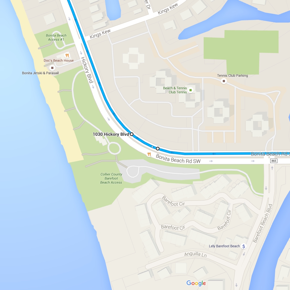
 Bonita Beach Rd [865] continues into Hickory Blvd (Little Hickory Island) where there are about nine public beach access points for Bonita Beach. Barefoot Beach is off to the left, just before Bonita Beach.
[Point of interest: Doc’s Beach House -a beach side restaurant - Looks interesting, but have not had the pleasure to review this place as of yet,].
 Hickory Blvd. then continues into Estero Blvd. [865] and onto Bays Island and Big Hickory Island which then passes through Long Key on your way to Estero Island.
[Point of interest: Lover’s Key State Park]
Traffic tends to get heavy on these islands so be prepared for lots of clutch work especially the closer you get to Fort Myers beach. There are about 25 public beach access points that stretch along Estero Island. Signs are posted to identify the access spots, however they are all down narrow little lanes with limited parking, also keep in mind they are metered.
We pulled off and ventured down one of the access points on Flamingo Street to have a break. This beach stop is less populated than the busy Fort Myers beach area, although every parking spot along the lane way was filled, that was not a problem for us and managed to squeeze into an opening. We were not going to stay long and took a short walk down the path to take a peak at the water.

By this time the mercury was already pushing 81 F (28 C) and I realized I still had my liner in my jacket. After a quick unzip I finally removed my liner so that I could continue the rest of our journey a little less sticky. (I should of done that miles back) As we were about to head out a very tanned, shirtless gentleman was heading toward the path to the beach and suggested I wear a bikini... hmmm... I know I seemed a little overdressed to be on the beach, but really, he did see I was on a bike....
As we neared Fort Myers Beach the more traffic backed up. I was lucky to even get past 2nd gear! It also didn’t help that there was some construction making the snails pace we were travelling at more of a sloths pace.
{Fun Fact: The Three-Toed Sloth is the slowest animal in the world and the name sloth is actually a synonym of slow motion. The top speed of a sloth is 0.003 miles per hour. They are so slow algae grow on them.}
In my experience, this is usually a good time of year to ride this route (Temperature wise and minimal crowds). Who would of figured that it would get so hot and humid since it hadn’t got past the mid 60's lately, so now this sweltering heat turned out the sun seekers in herds.
 Staying on Estero Boulevard we kept left before it continued into Sans Carlos Blvd so we could stop at Lynn Hall Memorial Park. I think that this is one of the larger parking areas available that is in close proximity to Fort Myers beach. Cars circle the lot like vultures ready to dive in as soon as an opening appears. Again, we of course didn’t have that problem <grin>.
Besides the beach, this area offers an interesting walk through Times Square with it’s quirky street performers, shops and beach side restaurants or one can meander down the pier - definitely a great place to people watch. However, I was melting by this point (on second thought, that bikini would of came in handy right about now) and wanted no part of people watching today, so after the much needed “P” stop, all I wanted to do was head home. I could already hear the ice cubes crackling in the cocktails.
Leaving Fort Myers Beach we headed over San Carlos Island
 [Point of Interest: Key West Express - the ferry from Fort Myers to Key West. There is also a restaurant there called the Parrot Key Caribbean Grill - I must check that out sometime, I just like the name. <smile>]
It was the middle of the afternoon and the traffic was bumper to bumper heading onto the Island, lucky for us we were leaving and our side of the road wasn’t too bad. Soon we were cruising down the road homeward bound.
It was going on 4 pm (way past my drink time) when we finally pulled in the driveway making this almost a one hundred mile tour. I peeled off my gear as fast as I could and got into more appropriate attire for the temperature and promptly poured a drink.

Until next time... ride it hard and keep it safe!
This is the kind of ride for those of you who like to pass through the action, get caught up in stop and go traffic and sweat you’re a** off when in full riding gear. Not recommended doing this ride during March when it really becomes congested with us Snowbirds. <grin>
The morning started out quite foggy, but by the time we were heading out the fog had burned off and it was turning out to be a nice day for a ride. Maybe a little too nice... Finally, the long awaited (somewhat) full-day tour since arriving in Florida.
I was really looking forward more to just the ride than actually having any destination to go to, so I chose this ride simply for that. We left shortly after 11 am and after making a quick stop to fill up my gas tank (a one tank ride) we were on our way heading out onto the dreaded Immokalee Rd. [82] in order to get onto Corkscrew Rd. (Where I started this ride on the map above)
Road Details
[Immokalee Road [82] is a two lane highway, and definitely not the most relaxing road to drive on. I have mentioned before that there are more accidents than there should be on this road. They drive way too fast and pass recklessly when they shouldn’t. There is a bit of construction going on now so I think they might be enlarging it, hopefully that will help this dangerous road and not hinder it. At least we didn’t have to stay on it long before hooking onto Corkscrew Road, which is a fairly fun road to travel on, it has some twists and turns, with one in particular which is pretty much a 90 degree corner. The road is paved and for the most part in good condition. There are some rough patches but really nothing to worry about. It is quite a “fast road” as the speed limit is 55 mph (88 km) and depending on the time of day you motor through just be aware that there are some very large trucks that use this road and they have a tendency to pass you like your standing still. (Even if you are going a little over the speed limit yourself. <smile>) You will pass through a lot of farmland and panther habitat on this route before coming to the more populated area where the gated communities take over.]
As we headed along Corkscrew Rd. we made a stop at the CREW Marsh Trails.
 {FYI: The Corkscrew Regional Ecosystem Watershed is 60,000 acres of land that collects, stores and cleans water for southwest Florida's drinking water supply. It also is a habitat for many threatened or endangered plants and animals. According to the signs posted the Florida panther, black bear, snail kite, gopher and tortoise along with species of rare ferns and orchids all make this area their home.}
  If you are inclined to be one with nature this place has a fairly extensive trail system to explore. Although today you would probably need hip waders to maneuver through most of the trails because of all the rain we have had over the month of January. Usually January is a fairly dry month in Florida, however this year Florida managed to have a record rainfall that produced 12.98 inches! Anyway, we weren’t there to hike on this occasion, we were on a mission to ride <smile> so onward we went...
Road Details
[Bonita Beach Road is a very busy and often congested road. It is a main artery to the beaches and has a collection of shops and restaurants lining both sides of the street. The road itself is smooth and in fairly good condition, so no worries there. In fact all the roads we travelled on this tour I couldn’t complain about.]
Points of interest: Naples Fort Myers Greyhound Racing & Poker
 Bonita Beach Rd [865] continues into Hickory Blvd (Little Hickory Island) where there are about nine public beach access points for Bonita Beach. Barefoot Beach is off to the left, just before Bonita Beach.
[Point of interest: Doc’s Beach House -a beach side restaurant - Looks interesting, but have not had the pleasure to review this place as of yet,].
 Hickory Blvd. then continues into Estero Blvd. [865] and onto Bays Island and Big Hickory Island which then passes through Long Key on your way to Estero Island.
 [Point of interest: Lover’s Key State Park]
Traffic tends to get heavy on these islands so be prepared for lots of clutch work especially the closer you get to Fort Myers beach. There are about 25 public beach access points that stretch along Estero Island. Signs are posted to identify the access spots, however they are all down narrow little lanes with limited parking, also keep in mind they are metered.
 |
| Not really a parking spot <grin> |

By this time the mercury was already pushing 81 F (28 C) and I realized I still had my liner in my jacket. After a quick unzip I finally removed my liner so that I could continue the rest of our journey a little less sticky. (I should of done that miles back) As we were about to head out a very tanned, shirtless gentleman was heading toward the path to the beach and suggested I wear a bikini... hmmm... I know I seemed a little overdressed to be on the beach, but really, he did see I was on a bike....
As we neared Fort Myers Beach the more traffic backed up. I was lucky to even get past 2nd gear! It also didn’t help that there was some construction making the snails pace we were travelling at more of a sloths pace.
{Fun Fact: The Three-Toed Sloth is the slowest animal in the world and the name sloth is actually a synonym of slow motion. The top speed of a sloth is 0.003 miles per hour. They are so slow algae grow on them.}
In my experience, this is usually a good time of year to ride this route (Temperature wise and minimal crowds). Who would of figured that it would get so hot and humid since it hadn’t got past the mid 60's lately, so now this sweltering heat turned out the sun seekers in herds.
 Staying on Estero Boulevard we kept left before it continued into Sans Carlos Blvd so we could stop at Lynn Hall Memorial Park. I think that this is one of the larger parking areas available that is in close proximity to Fort Myers beach. Cars circle the lot like vultures ready to dive in as soon as an opening appears. Again, we of course didn’t have that problem <grin>.
 Besides the beach, this area offers an interesting walk through Times Square with it’s quirky street performers, shops and beach side restaurants or one can meander down the pier - definitely a great place to people watch. However, I was melting by this point (on second thought, that bikini would of came in handy right about now) and wanted no part of people watching today, so after the much needed “P” stop, all I wanted to do was head home. I could already hear the ice cubes crackling in the cocktails.
Leaving Fort Myers Beach we headed over San Carlos Island
 [Point of Interest: Key West Express - the ferry from Fort Myers to Key West. There is also a restaurant there called the Parrot Key Caribbean Grill - I must check that out sometime, I just like the name. <smile>]
It was the middle of the afternoon and the traffic was bumper to bumper heading onto the Island, lucky for us we were leaving and our side of the road wasn’t too bad. Soon we were cruising down the road homeward bound.
It was going on 4 pm (way past my drink time) when we finally pulled in the driveway making this almost a one hundred mile tour. I peeled off my gear as fast as I could and got into more appropriate attire for the temperature and promptly poured a drink.

Until next time... ride it hard and keep it safe!
Subscribe to:
Posts (Atom)